EcoNet’s Conservation Activity Management System (CAMS) Weed Tool is built in Esri ArcGIS. EcoNet’s licensing means that we can have thousands of named users of the weed tool and other GIS apps.
The Weed tool is available on computer, phone or tablet.
The tool enables users to record a weed instance, details around the location and property and to record visit records on the weed instance.
One can quickly and easily record and update the core data about weed locations and their status.
New features allow you to optionally record:
• multiple visits to the weed location on different dates
• the height, area, number of stems present at the date visited
• the number of moth plant pods etc collected
• the number of volunteers who worked on the site and the hours they worked
• the treatment method and herbicide used (to allow tracking of the effectiveness of treatments)
Other features include:
• each volunteer has their own named user login
• layers to view property, reserves etc
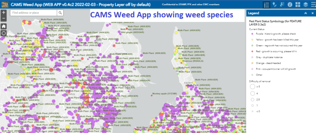
The following screenshot shows a section of eastern Auckland showing work completed as yellow or green and sites yet to be visited as purple or red. While the app makes it easy to work at the level of individual detail, a large scale map makes it easier to visualise progress and to identify areas needing attention. For example the following map shows high levels of volunteer effort in some areas (largely yellow and green) and a lot of work needed in others.
CAMS weed tool is one of many in our development road map.
To access the weed tool please contact us at systems@econet.nz